
Corridor Through the Mountains
Smith's Clove: Wartime Line of Communication and Passageway for the Continental Army, 1776-1783
Richard J. Koke
[Editor's Note: Richard J. Koke authored a series of five articles that appeared in Volumes 19 -23 of the OCHS Journal between 1990 and 1994. These articles will be presented in multiple sections over the next few years.]
Part VI:
The Blockhouse Door - And Afterward
Chapter 3:
Marking the Site
The earliest attempt to commemorate the Sidman fortifications had its inception in 1903 when James Bogert Suffern of Hillburn, a greatgrandson of the taverner, and his wife Sarah donated about a quarter of an acre of ground (7,183 square feet) in Fox Hollow to the New Jersey State Society of the Daughters of the Revolution "upon the express condition that the above premises shall be used for the preservation of the Revolutionary entrenchments thereon situated."
The Daughters, a local group chartered in 1898 and based at Ridgewood, New Jersey, operated as the Ramapo Valley Chapter and on June 28, 1904, dedicated a polished granite tablet fastened on a huge boulder on the earthworks at a ceremony attended by about 500 people at which Mr. Suffern and Clarence Lexow of Nyack delivered the principal addresses. The tablet and boulder are on the west side of Route 17, which is now routed through the hollow, and the inscription reads:
A. D. 1904
This tablet marks the site of
the post at Ramapough or Sidman's Bridge.
Erected by the
Ramapo Valley Chapter of Daughters of the Revolution
in honor of the officers and soldiers of
the Revolutionary War who were
stationed herefrom 1776 to 1781.
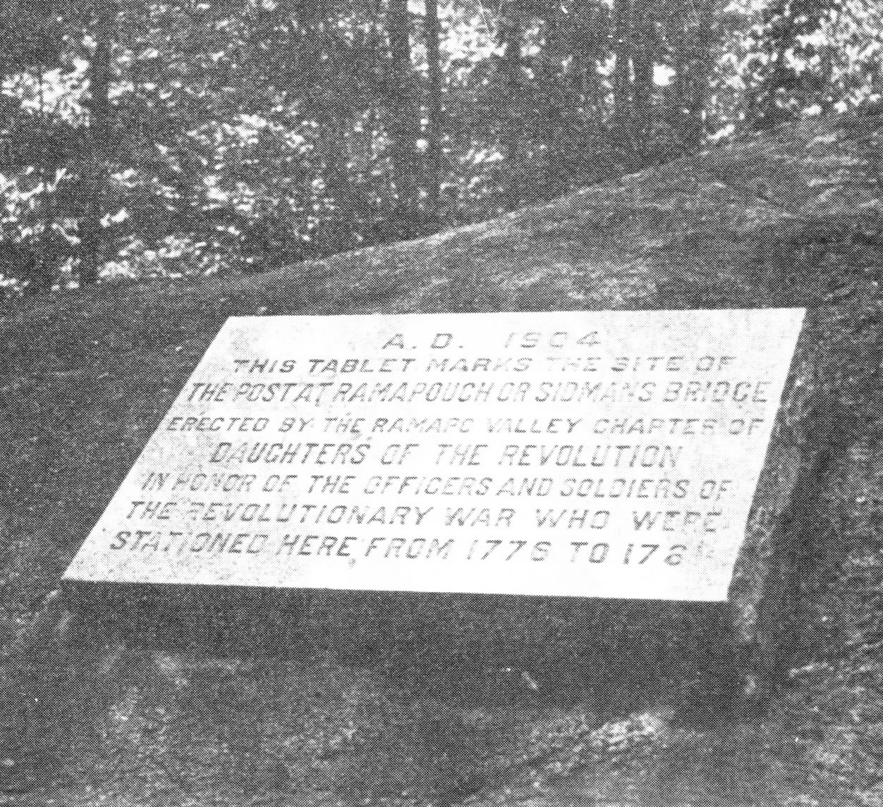 GRANITE TABLET erected in 1904 by the Daughters of the Revolution in Fox Hollow at Hillburn, Rockland County, to commemorate the military post at Sidman's bridge. The site on Route 17 is now owned by the Historical Society of Rockland County. Photograph by John Scott.
Annual observances by the Daughters were held at the site in June, with a short ceremony at which an ancestral roll of members was called and a spray of evergreen and oak, emblem of the Chapter, was placed on the rock. With an aging and declining membership, the pilgrimages gradually became increasingly difficult, and in 1979 the few remaining members transferred ownership of the ground to the Historical Society of Rockland County, which now maintains the site. The Ramapo Valley Chapter is no longer active and the last ladies involved are deceased.
In 1922, another tablet - this one of bronze mounted on a stone - was erected by the Rockland County Society on the line of Machin's entrenchment on the so-called "quarantine ground" on the west side of Torne Valley Road, close by the railroad and Route 59. The tablet was unveiled by little Eleanor Zabriskie of Suffern on property then owned by General J. Fred Pierson, and reads:
Erected May 13, 1922
Site of
Camp Ramapough and intrenchments
where Revolutionary troops were
stationed in 1776 and 1777. The
military works were erected by
General Washington to protect
the line of communication through
the Ramapo Pass.
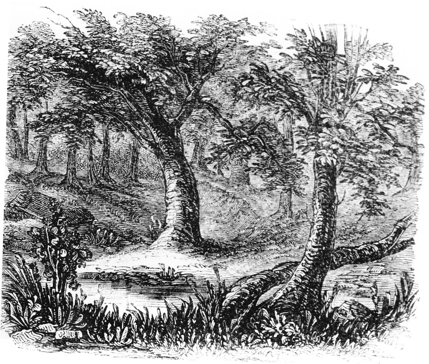 REMAINS OF REVOLUTIONARY WAR ENTRENCHMENTS 1850, constructed in November 1776 by Connecticut Continentals to block the Clove Road, now Route 59, below Sidman's bridge. Woodblock engraving by Benson John Lossing (1813-1891) from a pencil sketch by William M. McLeod (or MacLeod), published in 1851 in Harper's New York and Erie Rail-Road Guide Book.
Part I
Introduction
Clove and Precinct
The Clove Road
The Clove Taverns
Clove Taverns II
Part II
Prelude to War
The Continentals Arrive
Blocking the Clove
In the Midst of Tories
Offensive from the Highlands
The Militia Take Over
The Post at Ramapo
The Reluctant Militia
Holding the Line
An Embarrassing Situation
To Galloway's and Back
The Scotsman's Regiment
September Raid
Prelude for Disaster
Clinton Takes the Highlands
Sidman's Bridge: The Last Holdout
Part III
Introduction
Summer, 1778
A Cogent Appraisal
Villains and Robbers
Part IV
Introduction
Aaron Burr's Ride
March to the Clove
The Barren Clove
Bracing for Attack
Among the Rocks and Rattlesnakes
The Present Interesting Occasion
A Waiting Game
Redeployment
The Continental Road
The Taphouse Keeper's Daughter
The Indian Fighters Appear
March to Morristown
Part V
Introduction
A Fruitless Excursion
Summer at the Clove
A Frenchman's Journey
Pompton Mutiny: Blood in the Snow
Blockhouse in the Clove
The Allies at New Antrim
The Intercepted Messenger
A Questionable Story
What Really Happened
Perils of A Post Rider
New Yorkers at the Clove
Congress' Own Regiment
The Last Garrison
A Man of Passion
Homeless Canadians
The Last March
Part VI
Introduction
The Post at Sidman's Bridge
Marking the Site