
Corridor Through the Mountains
Smith's Clove: Wartime Line of Communication and Passageway for the Continental Army, 1776-1783
Richard J. Koke
[Editor's Note: Richard J. Koke authored a series of five articles that appeared in Volumes 19 -23 of the OCHS Journal between 1990 and 1994. These articles will be presented in multiple sections over the next few years.]
Part VI:
The Blockhouse Door - And Afterward
Chapter 2:
The Post at Sidman's Bridge
Sidman's bridge, where Route 59 - the old Clove Road - crosses the Ramapo River and where the military post of 1776-1783 was situated within the lower entrance to Smith's Clove, is now a forgotten name. Vestiges of the earthwork laid out by Lieutenant Thomas Machin in 1776 across the narrow gorge below the bridge to block an enemy advance from the south remained into the 20th century. The only contemporary description of this barrier between the mountain and the river, through which the Clove Road passed, was that of Colonel Jedediah Huntington in November 1776 who described it as "a musketry line."
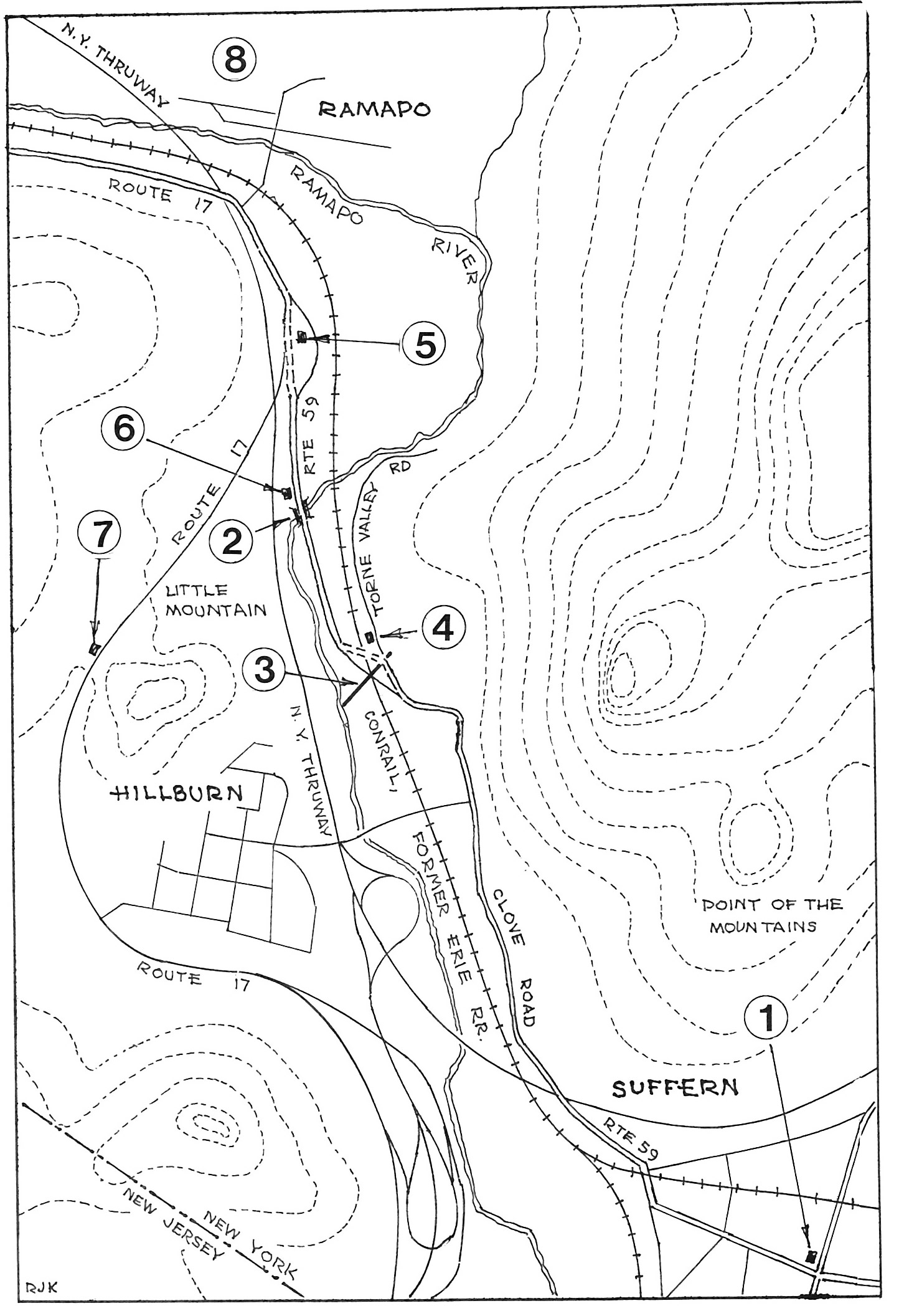 LOWER ENTRANCE TO SMITH'S CLOVE sometimes called Sidman's Clove and later the Ramapo Pass. 1. Site of John Suffern's tavern, northwest corner of Washington and Lafayette avenues, Suffern. 2. Sidman's Bridge across the Ramapo River. 3. Line of American entrenchment, constructed November 1776 between the mountain and Ramapo River, as indicated on R. E. O'Connor map of Rockland County, 1854. 4. Tablet, 1922, Torne Valley Road, marking Ramapo entrenchment. 5. Former Ramapo Presbyterian Church and graveyard, junction of Routes 17 and 59. Approximate site of "Little redoubt" of 1776, the "old fort" depicted on Erskine maps and the blockhouse of 1781-83. The Revolutionary War barracks for the Sidman garrison were probably also in this area. 6. Site of Shuart's house, Route 59, American Revolution. 7. Fox Hollow Tablet, 1904, Route 17, Hillburn, commemorating the post at Ramapo. 8. Ramapo Works, important 19th-century industrial village, now vanished, established 1795 by Josiah and Jeremiah Pierson on land purchased from John Suffern.
The site was thereafter well remembered. In 1850 Benson Lossing wrote that the embankment, overgrown with trees, was "quite prominent" and "with care these mementoes of the past may be long preserved." A year later the remains were pointed out as an attraction for passengers in Harper's New York and Erie Railroad Guide Book, with which Lossing was associated as an illustrator. Marked as an "Intrenchment," the barrier is indicated as a dotted line across the pass on R. E. O'Connor's Map of Rockland County in 1854, and in 1859 the site was marked as "Quarantine in 1778. Gen.l Morgan's Intrenchment" on Corey and Bachman's Map of Orange and Rockland Cos. According to Colonel William Winthrop of the United States Army, who visited the locality in the 1880s, the remains consisted of a well defined embankment about 150 feet long and about ten broad stretching across a field near the river and as late as 1927 the ground was marked as "Fort Ramapough Site" on a topographical map of the Bear Mountain-Harriman Section of the Palisades Interstate Park. When visited by the present writer in 1952, the last trace of the entrenchment close to the mountain had recently been graded and obliterated.
The "little redoubt" of 1776, the "Old Fort" shown on the Erskine maps and the blockhouse of 1781-83 were all north of the bridge in the vicinity of the present junction of Routes 17 and 59. The precise locations of the barracks of 1776-80 are not known, but they undoubtedly stood on the level ground north of the bridge between Route 17 and the Ramapo River, later tilled by the Pierson family and utilized as a right-of-way for the Erie Railroad.
The "Quarantine in 1778" cited on the Corey and Bachman map evidently had some basis in prevailing local folklore. According to the chronicles of the Belcher family of Sloatsburg, Eleanor L. Belcher related to her sons in the middle 1800s "that a South [sic] Carolina regiment was encamped near Ramapo Pass and that many of them died from smallpox," and prior to the Civil War "a score of graves marked by flat stones with no inscriptions" could be seen below Sloatsburg "on the road to Ramapo," which were also seen by William H. Belcher. William, in turn, affirmed his belief "that these were undoubtedly the last resting places of the men who were carried off by smallpox in the Revolution, as related by his mother. The road which passes that locality," he said, "is now abandoned and a new road made, and no one seems to know anything about these neglected memorials of the brave men whose lives were sacrificed there for their country."
The location of these graves is not known, but what is interesting is the enduring remembrance over a period of more than half a century of a Carolina presence in the corridor, despite the brevity of their stay for only a few weeks at the close of 1778 when the North Carolina brigade - not South Carolina - was posted in the Clove to prevent deserters from Burgoyne's captive army from making their way through the corridor to New York.
The quarantine story persisted for generations and even as late as 1909, according to Theophilus N. Glover, writing for the Bergen County Historical Society, the area below Sidman's bridge was still called the "Quarantine Ground," and with it a tradition "of the complete annihilation of a Carolina regiment...by camp fever" and that the graves were "plainly visible twenty-five years ago." Contrary to this recurring tale, however, contemporary wartime sources make no mention whatsoever of a quarantine camp, nor deaths by smallpox, nor is there any known connection with the entrenchment with Daniel Morgan, who in November 1778 was a colonel and not a general when on temporary duty at Pompton.
The construction of the New York Thruway and realignment of the Ramapo River along the base of Little Mountain in the 1950s and the major highway alterations of the 1990s for the linkage of the Thruway with Interstate 287 took their toll of the ground on both sides of the river where the military post had been located. The convergence of highways into the corridor, in another sense, could only serve, however, to reemphasize the importance given this great pass in the defense strategy of the Hudson Highland command during the Revolutionary War.
When Colonel William Winthrop journeyed to the Ramapos in the 1880s to search out the remains of the Sidman fortifications, his attention was also directed to another entrenchment in Fox Hollow on the upland ridge west of the Ramapo behind Little Mountain at Hillburn, about a mile below the junction of Routes 17 and 59.
This earthwork, stretching across the narrow defile overlooking the valley, may well have been intended as a protective cover to secure the Sidman position at the bridge against a flank attack from the Jersey side by way of the tangled Hillburn country and through the hollow that could open the way for a hostile descent onto the flank and rear of the Sidman post from the high ground to the southwest.
The possibility of such a move was more than inherent in November 1776 when the Jersey tories were openly boasting that they would guide the British to the Clove to surround and cut off the hard-pressed Continental garrison under Colonels Huntington and Tyler. Winthrop described the Fox Hollow remains as a grassy mound about 100 feet long, fifteen to twenty broad and from four to five feet high. Today it is woodland.
Part I
Introduction
Clove and Precinct
The Clove Road
The Clove Taverns
Clove Taverns II
Part II
Prelude to War
The Continentals Arrive
Blocking the Clove
In the Midst of Tories
Offensive from the Highlands
The Militia Take Over
The Post at Ramapo
The Reluctant Militia
Holding the Line
An Embarrassing Situation
To Galloway's and Back
The Scotsman's Regiment
September Raid
Prelude for Disaster
Clinton Takes the Highlands
Sidman's Bridge: The Last Holdout
Part III
Introduction
Summer, 1778
A Cogent Appraisal
Villains and Robbers
Part IV
Introduction
Aaron Burr's Ride
March to the Clove
The Barren Clove
Bracing for Attack
Among the Rocks and Rattlesnakes
The Present Interesting Occasion
A Waiting Game
Redeployment
The Continental Road
The Taphouse Keeper's Daughter
The Indian Fighters Appear
March to Morristown
Part V
Introduction
A Fruitless Excursion
Summer at the Clove
A Frenchman's Journey
Pompton Mutiny: Blood in the Snow
Blockhouse in the Clove
The Allies at New Antrim
The Intercepted Messenger
A Questionable Story
What Really Happened
Perils of A Post Rider
New Yorkers at the Clove
Congress' Own Regiment
The Last Garrison
A Man of Passion
Homeless Canadians
The Last March
Part VI
Introduction
The Post at Sidman's Bridge
Marking the Site